Do you enjoy solving mysteries? Here’s one that will take
you out into the fresh air for a walk through lush British countryside in search of clues.
 |
| Photo by Joe Cornish for the National Trust |
Before the development of modern transport, handlers moved
their livestock on foot from pasture to town along set routes now known as
drover roads. Livestock might include cattle, sheep, pigs or even geese.
Of course many of these roads are still in use. But many
more have vanished back into the landscape.
Bruce Smith, a retiree living near Brackley in
Northamptonshire, began seeking out these lost roads in 2005. He shared his
passion for the subject at the Buckinghamshire Family History Society meeting
at the Queensway Methodist Church Hall in Bletchley.
On his web site, localdroveroads.co.uk, Mr. Smith says, “The main
purpose of country roads used to be for moving beasts, so most of the roads we
drive along were made by or for drovers. Ones not tarmacked are now byways or
bridleways, many have vanished altogether or been built upon. But there is
still a vast network criss-crossing the British countryside.
“To come across an old road untouched by the 20th century is for me an utter joy: 200 years seem to slide off my shoulders.”
“To come across an old road untouched by the 20th century is for me an utter joy: 200 years seem to slide off my shoulders.”
To find the old roads, there are a number of clues. First,
look at the place names. According to Mr. Smith, drover’s roads tend to be named
lane or way. Some are obvious, such as Drovers Arms for an inn or Bullock Way.
Place names in England that refer to Wales are also good clues. Rother, the old
English name for cattle, is also a giveaway. Names that include ox, cow or cat
(for cattle) are almost always indicators of the drovers’ routes.
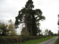 |
| Photo from localdroveroads.co.uk |
Inns that catered to drovers tended to cluster at the edge of
town, to ensure that the cattle had plenty of pasture for grazing. Generally
these inns had plenty of outbuildings or pasture nearby.
Drovers would also plant a cluster of three Scots Pines to
indicate an obscure turn or a favoured inn or grazing patch.
Another way to find an old drove road is to pay attention
whilst driving. If the new road turns while the old road continues straight on,
often the old road was a drove road. Wide verges, once needed for grazing, are also
a sign the road once served the drovers and their cattle. Narrow fields running
parallel to a road may indicate old grazing routes.
Mr. Smith has identified a number of drover’s routes in
Buckinghamshire. Here is a link to his web site with photos and further information
about the old roads.
Nice piece! And of course I can't leave without noting that the drovers were ably assisted by their collies, curs, corgis and sheepdogs.
ReplyDeleteThat's true! According to Bruce Smith Corgis, a true Welsh breed, were the best. One drover and two corgis often had charge of a whole herd!
DeleteWe have an old drove road on our farm - and three Scots Pines and an old drover well which is 60ft deep and 5ft across - its called the Green lane - Y lôn werdd in Welsh
ReplyDeleteHow interesting. Is that in Oxfordshire or Buckinghamshire? I'm sure Bruce Smith would love to hear from you at his web site at www.localdroveroads.co.uk. He's still collecting information on the subject.
ReplyDeleteHere's a link to Walkingworld's page on drovers' roads: http://www.walkingworld.com/Articles/Pathways/Pathways/Drovers--roads.aspx, for those who are interested.
ReplyDeleteHi Lynette: I'm honoured to be on your blog and thank you for taking such an interest. I'll keep up with you now & again. Good luck in your travels.
ReplyDeleteI wonder if Ann Edwards would give me the postcode of y lon werdd? I go to Wales quite often (Bow Street last year) and would like to put the farm on my "trail map".
Best wishes
Bruce
Thanks Bruce. I found your talk quite enjoyable. I'll pass your message on to Ann.
ReplyDelete